Karabakh has a total area of 4,400 square kilometers (1,699 square miles) and lies on the southwest part of Azerbaijan bordering Armenia and Azerbaijan. It has tall mountain ridges along the northern, western and southern boundaries and flat valley’s throughout the eastern part of the territory.
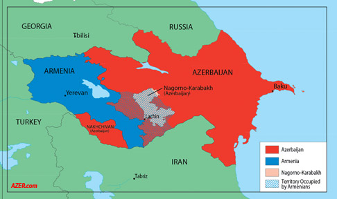
The region encloses five administrative districts of Azerbaijan: Askaran, Hadrut, Agdere, Khojavand and Shusha. The main town is Khankandi, and its other major city, today lying partially in ruins, is Shusha.
The region of Nagorno-Karabakh is an enclave surrounded entirely by Azerbaijan; its nearest point to Armenia is across the Lachin corridor, roughly 4 kilometers across.
- Topography and Terrain:
Karabakh’s topography is characterized by a blend of mountainous landscapes and fertile valleys. The region is adorned with the Lesser Caucasus mountain range, which meanders through its heart, contributing to the breathtaking scenery that defines Karabakh. Peaks such as Mount Mrav and Mount Tigh present not only formidable natural barriers but also offer panoramic views of the surrounding valleys. - Mountainous Majesty:
The mountainous terrain of Karabakh contributes to its rugged beauty and has played a crucial role in shaping the region’s cultural and historical development. Mountain ranges create natural borders, influencing settlement patterns and fostering the development of distinctive communities nestled in the protective embrace of the peaks. - Fertile Valleys and River Networks:
Amidst the mountains, Karabakh is blessed with fertile valleys nurtured by river networks. The Khachen River, Tartar River, and other tributaries weave through the landscape, providing sustenance to the region’s agricultural activities. These valleys, cradled by the surrounding mountains, have historically been vital hubs for human settlement and economic activities. - Climate Variability:
Karabakh experiences a diverse range of climates due to its varied topography. The mountainous areas boast a cooler, alpine climate, while the valleys enjoy milder temperatures. Summers are generally warm, with cooler temperatures prevailing at higher elevations. Winters can bring snowfall to the mountainous regions, creating a picturesque winter landscape. - Biodiversity and Flora:
The geographical diversity of Karabakh contributes to a rich tapestry of flora and fauna. The region is home to a variety of plant species adapted to different elevations, from alpine meadows to lush valleys. The mountains provide habitats for diverse wildlife, including species like the Caucasian red deer and the Bezoar goat, adding to the ecological significance of the region. - Cultural Significance of Landscape:
The geography of Karabakh is deeply interwoven with its cultural and historical narrative. The towering mountains, fertile valleys, and flowing rivers have not only influenced the livelihoods of its inhabitants but also inspired artistic expressions, folklore, and the spiritual connection of the people to their land.
Karabakh’s geography is a testament to the harmonious coexistence of diverse natural elements. The interplay between mountains and valleys, rivers and meadows, creates a landscape that is not only visually stunning but also integral to the identity of the region. As we navigate through the geographical tapestry of Karabakh, we gain a deeper appreciation for the interdependence between the land and its people, shaping a region whose allure extends beyond its historical and cultural significance.